Title:
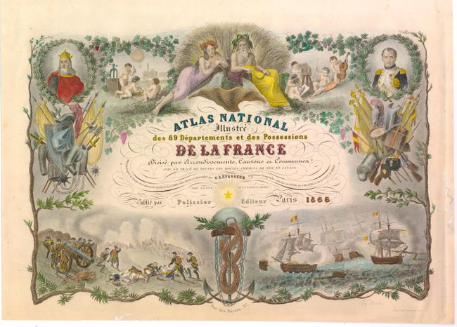
“Atlas National Illustre des 89 Departements et des Possessions de la France Divise par Arrondissements, Cantons et Communes...”
Map Maker:
Victor Levasseur
Attractive title page from one of the last decorat... (full text available to subscribers)
| Item Detail |
| |
| |
MapMaker: |
Victor Levasseur
|
|
| |
| |
Subject: |
Title Pages |
|
| |
Period/Size: |
1866 / 12.0" x 16.5" (30.5 x 42.0 cm)
|
|
| |
Color: |
Colored
|
|
| |
Condition: |
(B+ ) A few small tears in blank margins have been repaired with tape. Ink marks appear in right and bottom margins, away from image. One small abrasion by the ships. (condition help) |
|
| |
Source: |
|
|
| |
References: |
|
|
| |
|
|
| Sales Information |
| |
| |
Price: |
|
|
| |
| |
Offered by: |
Old World Auctions |
|
| |
Catalog: |
Auction No. 142 - Antique Maps, Charts, Atlases & Globes (9038) |
|
| |
Lot/Item #: |
12 |
|
| |
| |
Date: |
12/2012
|
|
| |
| |
|
Antique Maps - Valuation and Pricing, Descriptions, Resources |
|
Home |
Information |
Search |
Register |
Contact Us |
Site Map
Americana Exchange, Inc. © 1999 - 2024 Americana Exchange, Inc.. All rights reserved.
OldMaps.com, the OldMaps.com logo and
AMPR are service marks or registered service marks of Americana Exchange, Inc..
|