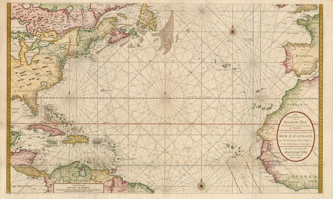
Title:
“Nieuwe Wassende Graade Zee Kaart over de Spaanse Zee van't Kanaal tot 't Eyland Cuba in Westindia / Nouvelle Carte Marine Reduite de la Mer. D. Espagne / The New Sea Map of the Spannish Zee”
Map Maker:
Gerard van Keulen
This sea chart of the Atlantic is filled with plac... (full text available to subscribers)
| Item Detail |
| |
| |
MapMaker: |
Gerard van Keulen
|
|
| |
| |
Subject: |
Atlantic Ocean |
|
| |
Period/Size: |
1710 / 23.5" x 39.0" (59.7 x 99.1 cm)
|
|
| |
Color: |
Colored
|
|
| |
Condition: |
(B+ ) There are professional repairs to separations and several small holes along a horizontal fold towards bottom with a small amount of map in facsimile and minute loss of image. There are a few small spots and minor soiling. Overall still a very nic (condition help) |
|
| |
Source: |
|
|
| |
References: |
|
|
| |
|
|
| Sales Information |
| |
| |
Price: |
|
|
| |
| |
Offered by: |
Old World Auctions |
|
| |
Catalog: |
Auction No. 142 - Antique Maps, Charts, Atlases & Globes (9038) |
|
| |
Lot/Item #: |
387 |
|
| |
| |
Date: |
12/2012
|
|
| |
| |
|
Antique Maps - Valuation and Pricing, Descriptions, Resources |
|
Home |
Information |
Search |
Register |
Contact Us |
Site Map
Americana Exchange, Inc. © 1999 - 2024 Americana Exchange, Inc.. All rights reserved.
OldMaps.com, the OldMaps.com logo and
AMPR are service marks or registered service marks of Americana Exchange, Inc..
|