Title:
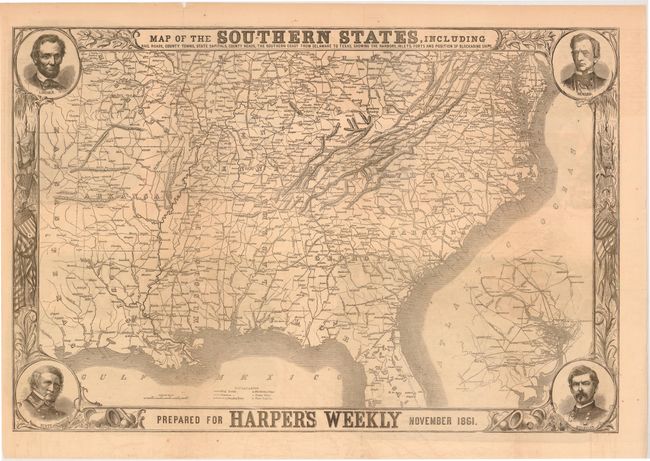
“Map of the Southern States, Including Railroads, County Towns, State Capitals, County Roads, the Southern Coast from Delaware to Texas, Showing the Harbors, Inlets, Forts and Position of Blockading Ships…”
Map Maker:
Harper & Brothers
This terrific Civil War map shows good deta... (full text available to subscribers)
| Item Detail |
| |
| |
MapMaker: |
Harper & Brothers
|
|
| |
| |
Subject: |
Southern United States |
|
| |
Period/Size: |
1861 / 20.0" x 30.0" (50.8 x 76.2 cm)
|
|
| |
Color: |
Black & White
|
|
| |
Condition: |
(B ) Issued folding with some light offsetting, a few minor spots, and numerous long, clean fold separations that have been closed on verso with archival tape and paper tape. (condition help) |
|
| |
Source: |
|
|
| |
References: |
Stephenson (CW) 14.55; Rumsey #5309.001. |
|
| |
|
|
| Sales Information |
| |
| |
Price: |
|
|
| |
| |
Offered by: |
Old World Auctions |
|
| |
Catalog: |
Auction No. 142 - Antique Maps, Charts, Atlases & Globes (9038) |
|
| |
Lot/Item #: |
188 |
|
| |
| |
Date: |
12/2012
|
|
| |
| |
|
Antique Maps - Valuation and Pricing, Descriptions, Resources |
|
Home |
Information |
Search |
Register |
Contact Us |
Site Map
Americana Exchange, Inc. © 1999 - 2024 Americana Exchange, Inc.. All rights reserved.
OldMaps.com, the OldMaps.com logo and
AMPR are service marks or registered service marks of Americana Exchange, Inc..
|