Title:
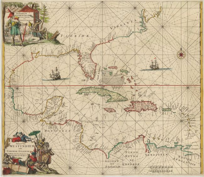
“Indiarum Occidentalium Tractus Littorales cum Insulis Caribicis ... / Pascaert van Westindien ende Caribise Eylanden…”
Map Maker:
Frederick de Wit
This is the scarce first edition of one of the mos... (full text available to subscribers)
| Item Detail |
| |
| |
MapMaker: |
Frederick de Wit
|
|
| |
| |
Subject: |
Gulf of Mexico and Caribbean |
|
| |
Period/Size: |
1680 / 19.2" x 22.2" (48.8 x 56.4 cm)
|
|
| |
Color: |
Colored
|
|
| |
Condition: |
(B+ ) A nice impression with some professionally repaired 1-2" tears in image. Backed in Japanese tissue. (condition help) |
|
| |
Source: |
Orbis Maritimus ofte Zee Atlas |
|
| |
References: |
|
|
| |
|
|
| Sales Information |
| |
| |
Price: |
|
|
| |
| |
Offered by: |
Old World Auctions |
|
| |
Catalog: |
Auction No. 142 - Antique Maps, Charts, Atlases & Globes (9038) |
|
| |
Lot/Item #: |
316 |
|
| |
| |
Date: |
12/2012
|
|
| |
| |
|
Antique Maps - Valuation and Pricing, Descriptions, Resources |
|
Home |
Information |
Search |
Register |
Contact Us |
Site Map
Americana Exchange, Inc. © 1999 - 2024 Americana Exchange, Inc.. All rights reserved.
OldMaps.com, the OldMaps.com logo and
AMPR are service marks or registered service marks of Americana Exchange, Inc..
|