Title:
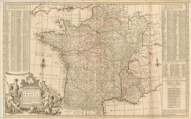
“A New and Exact Map of France Dividid into all its Provinces and Acquisitions, According to the Newest Observations, and that Accurate Survey Made by the King's Command by Mr. Picar and de la Hire…”
Map Maker:
Herman Moll
This decorative two-sheet map of France is filled ... (full text available to subscribers)
| Item Detail |
| |
| |
MapMaker: |
Herman Moll
|
|
| |
| |
Subject: |
France |
|
| |
Period/Size: |
1730 / 23.8" x 38.3" (60.5 x 97.3 cm)
|
|
| |
Color: |
Colored
|
|
| |
Condition: |
(B+ ) Original outline color with light toning along folds and a few small spots. Long fold separations at bottom have been professionally repaired. (condition help) |
|
| |
Source: |
|
|
| |
References: |
Shirley (BL Atlases) #T.Moll-4b [23]. |
|
| |
|
|
| Sales Information |
| |
| |
Price: |
|
|
| |
| |
Offered by: |
Old World Auctions |
|
| |
Catalog: |
Auction No. 142 - Antique Maps, Charts, Atlases & Globes (9038) |
|
| |
Lot/Item #: |
466 |
|
| |
| |
Date: |
12/2012
|
|
| |
| |
|
Antique Maps - Valuation and Pricing, Descriptions, Resources |
|
Home |
Information |
Search |
Register |
Contact Us |
Site Map
Americana Exchange, Inc. © 1999 - 2024 Americana Exchange, Inc.. All rights reserved.
OldMaps.com, the OldMaps.com logo and
AMPR are service marks or registered service marks of Americana Exchange, Inc..
|