Title:
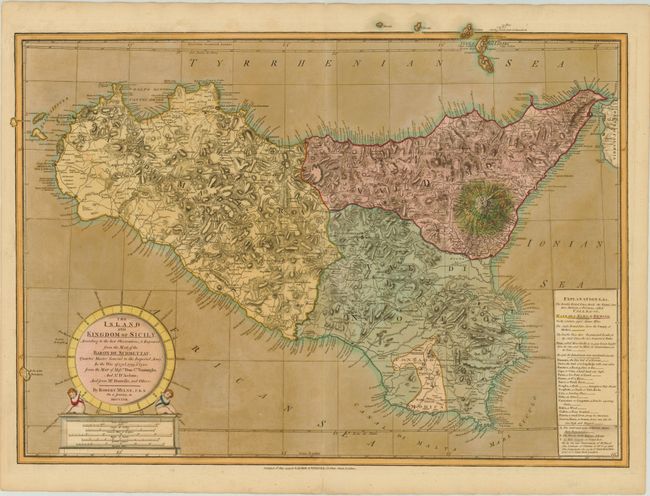
“The Island and Kingdom of Sicily, According to the Best Observations, & Improved; from the Map, of the Baron de Schmettau, Quarter Master General to the Imperial Army, in the War of 1718, 1719, & 1720…”
Map Maker:
Robert Mylne
Robert Mylne, a Scottish architect and civil engin... (full text available to subscribers)
| Item Detail |
| |
| |
MapMaker: |
Robert Mylne
|
|
| |
| |
Subject: |
Sicily, Italy |
|
| |
Period/Size: |
1799 / 19.4" x 26.8" (49.3 x 68.1 cm)
|
|
| |
Color: |
Colored
|
|
| |
Condition: |
(B+ ) Original color with oxidation in the sea. The paper is still very sturdy. There are tissue repairs on short centerfold separations in top and bottom blank margins. (condition help) |
|
| |
Source: |
A New Universal Atlas |
|
| |
References: |
|
|
| |
|
|
| Sales Information |
| |
| |
Price: |
|
|
| |
| |
Offered by: |
Old World Auctions |
|
| |
Catalog: |
Auction No. 142 - Antique Maps, Charts, Atlases & Globes (9038) |
|
| |
Lot/Item #: |
577 |
|
| |
| |
Date: |
12/2012
|
|
| |
| |
|
Antique Maps - Valuation and Pricing, Descriptions, Resources |
|
Home |
Information |
Search |
Register |
Contact Us |
Site Map
Americana Exchange, Inc. © 1999 - 2024 Americana Exchange, Inc.. All rights reserved.
OldMaps.com, the OldMaps.com logo and
AMPR are service marks or registered service marks of Americana Exchange, Inc..
|