Title:
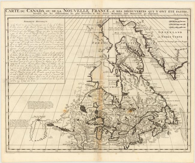
“Carte du Canada ou de la Nouvelle France, & des Decouvertes qui y ont ete Faites, Dressee sur les Observations les Plus Nouvelles, & sur Divers Memoires Tant Manuscrits qu'Imprimez”
Map Maker:
Henry Abraham Chatelain
This richly detailed map, copied from Delisle, pro... (full text available to subscribers)
| Item Detail |
| |
| |
MapMaker: |
Henry Abraham Chatelain
|
|
| |
| |
Subject: |
Colonial United States & Canada, Great Lakes |
|
| |
Period/Size: |
1719 / 16.0" x 20.5" (40.7 x 52.1 cm)
|
|
| |
Color: |
Black & White
|
|
| |
Condition: |
(B ) A crisp impression on watermarked paper with toning along centerfold and two small stains. (condition help) |
|
| |
Source: |
Atlas Historique, Tome VI |
|
| |
References: |
Kershaw #334; Phillips (A) #548. |
|
| |
|
|
| Sales Information |
| |
| |
Price: |
|
|
| |
| |
Offered by: |
Old World Auctions |
|
| |
Catalog: |
Auction No. 141 - Antique Maps, Charts, Atlases & Globes (9037) |
|
| |
Lot/Item #: |
126 |
|
| |
| |
Date: |
09/2012
|
|
| |
| |
|
Antique Maps - Valuation and Pricing, Descriptions, Resources |
|
Home |
Information |
Search |
Register |
Contact Us |
Site Map
Americana Exchange, Inc. © 1999 - 2024 Americana Exchange, Inc.. All rights reserved.
OldMaps.com, the OldMaps.com logo and
AMPR are service marks or registered service marks of Americana Exchange, Inc..
|