Title:
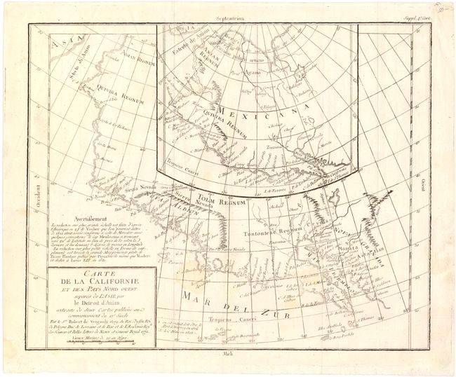
“Carte de la Californie et des Pays Nord-Ouest separes de l'Asie par le Detroit d'Anian, extraite de deux cartes publiees au commencement du 17e siecle”
Map Maker:
Didier Robert de Vaugondy
Two contrasting maps, one inset into the other. T... (full text available to subscribers)
| Item Detail |
| |
| |
MapMaker: |
Didier Robert de Vaugondy
|
|
| |
| |
Subject: |
Western North America |
|
| |
Period/Size: |
1772 / 12.5" x 14.0" (31.8 x 35.6 cm)
|
|
| |
Color: |
Black & White
|
|
| |
Condition: |
(B+) Issued folding and now flat on watermarked paper with a few small damp stains in the image. (condition help) |
|
| |
Source: |
Diderot's Encyclopedia (Supplement) |
|
| |
References: |
Wheat (TMW) #159; Wagner (NW) #632; Pedley #473. |
|
| |
|
|
| Sales Information |
| |
| |
Price: |
|
|
| |
| |
Offered by: |
Old World Auctions |
|
| |
Catalog: |
Auction No. 143 - Antique Maps, Charts, Atlases & Globes (9042) |
|
| |
Lot/Item #: |
141 |
|
| |
| |
Date: |
02/2013
|
|
| |
| |
|
Antique Maps - Valuation and Pricing, Descriptions, Resources |
|
Home |
Information |
Search |
Register |
Contact Us |
Site Map
Americana Exchange, Inc. © 1999 - 2024 Americana Exchange, Inc.. All rights reserved.
OldMaps.com, the OldMaps.com logo and
AMPR are service marks or registered service marks of Americana Exchange, Inc..
|