Title:
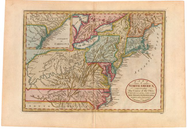
“Part of North America, Comprehending the Course of the Ohio, New England, New York, New Jersey, Pennsylvania, Maryland, Virginia, Carolina & Georgia”
Map Maker:
John Cary
A finely engraved map based on the larger map by D... (full text available to subscribers)
| Item Detail |
| |
| |
MapMaker: |
John Cary
|
|
| |
| |
Subject: |
Eastern United States |
|
| |
Period/Size: |
1795 / 8.3" x 11.6" (21.1 x 29.5 cm)
|
|
| |
Color: |
Colored
|
|
| |
Condition: |
(B+) Attractive color with light, even toning, minor soiling and offsetting, and a short printer's crease at top. (condition help) |
|
| |
Source: |
Guthrie's Universal Geography Improved |
|
| |
References: |
McCorkle #782.9. |
|
| |
|
|
| Sales Information |
| |
| |
Price: |
|
|
| |
| |
Offered by: |
Old World Auctions |
|
| |
Catalog: |
Auction No. 143 - Antique Maps, Charts, Atlases & Globes (9042) |
|
| |
Lot/Item #: |
179 |
|
| |
| |
Date: |
02/2013
|
|
| |
| |
|
Antique Maps - Valuation and Pricing, Descriptions, Resources |
|
Home |
Information |
Search |
Register |
Contact Us |
Site Map
Americana Exchange, Inc. © 1999 - 2024 Americana Exchange, Inc.. All rights reserved.
OldMaps.com, the OldMaps.com logo and
AMPR are service marks or registered service marks of Americana Exchange, Inc..
|