Title:
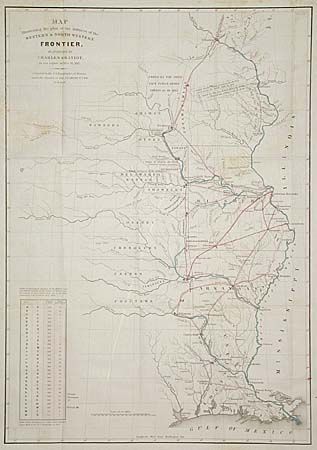
“Map Illustrating the plan of the defences of the Western & North-Western Frontier, as proposed by Charles Gratiot in his report of Oct. 31, 1837”
Map Maker:
Charles Gratiot
The map depicts the states of Missouri, Arkansas, ... (full text available to subscribers)
| Item Detail |
| |
| |
MapMaker: |
Charles Gratiot
|
|
| |
| |
Subject: |
Central United States |
|
| |
Period/Size: |
1838 / 21.5" x 15.2" (54.7 x 38.6 cm)
|
|
| |
Color: |
Colored
|
|
| |
Condition: |
(B) Two areas of light foxing and the colorist dropped a red smudge in margin and just at the neatline. (condition help) |
|
| |
Source: |
Senate doc 65, 25th Cong., 2nd Session |
|
| |
References: |
|
|
| |
|
|
| Sales Information |
| |
| |
Price: |
|
|
| |
| |
Offered by: |
Old World Auctions |
|
| |
Catalog: |
Auction No. 96 - Antique Maps, Charts, Atlases & Globes (168) |
|
| |
Lot/Item #: |
148 |
|
| |
| |
Date: |
09/2001
|
|
| |
| |
|
Antique Maps - Valuation and Pricing, Descriptions, Resources |
|
Home |
Information |
Search |
Register |
Contact Us |
Site Map
Americana Exchange, Inc. © 1999 - 2024 Americana Exchange, Inc.. All rights reserved.
OldMaps.com, the OldMaps.com logo and
AMPR are service marks or registered service marks of Americana Exchange, Inc..
|