Title:
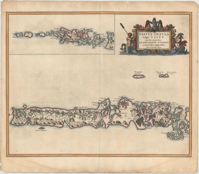
“Vistus Insula, vulgo Viist, cum aliis minoribus ex Aebudarum Numero ei ad meridiem adjacentibus Auct. Timotheo Pont”
Map Maker:
Johannes Blaeu
This stunning map of the Uists and Barra in the Ou... (full text available to subscribers)
| Item Detail |
| |
| |
MapMaker: |
Johannes Blaeu
|
|
| |
| |
Subject: |
Outer Hebrides, Scotland |
|
| |
Period/Size: |
1654 / 17.6" x 22.6" (44.7 x 57.4 cm)
|
|
| |
Color: |
Colored
|
|
| |
Condition: |
(B+) A fine sharp impression with old color. There is some faint ink offsetting in the map with light damp stains and professionally repaired tears in the blank margins. (condition help) |
|
| |
Source: |
Atlas Novus |
|
| |
References: |
Fleet, http://maps.nls.uk/atlas/blaeu/history_behind_publication.html |
|
| |
|
|
| Sales Information |
| |
| |
Price: |
|
|
| |
| |
Offered by: |
Old World Auctions |
|
| |
Catalog: |
Auction No. 143 - Antique Maps, Charts, Atlases & Globes (9042) |
|
| |
Lot/Item #: |
460 |
|
| |
| |
Date: |
02/2013
|
|
| |
| |
|
Antique Maps - Valuation and Pricing, Descriptions, Resources |
|
Home |
Information |
Search |
Register |
Contact Us |
Site Map
Americana Exchange, Inc. © 1999 - 2024 Americana Exchange, Inc.. All rights reserved.
OldMaps.com, the OldMaps.com logo and
AMPR are service marks or registered service marks of Americana Exchange, Inc..
|