Title:
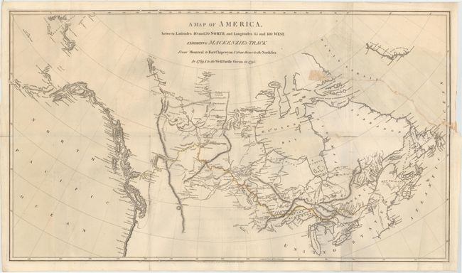
“A Map of America, from Latitudes 40 and 70 North, and Longitudes 45 and 180 West, Exhibiting Mackenzie's Track from Montreal to Fort Chipewyan & from Thence to the North Sea in 1789, & to the West Pacific Ocean in 1793”
Map Maker:
Alexander Mackenzie
Alexander Mackenzie was the first white man to cro... (full text available to subscribers)
| Item Detail |
| |
| |
MapMaker: |
Alexander Mackenzie
|
|
| |
| |
Subject: |
Canada |
|
| |
Period/Size: |
1801 / 7.0" x 11.0" (17.8 x 28.0 cm)
|
|
| |
Color: |
Colored
|
|
| |
Condition: |
(B) There is an edge tear at right that extends 9.5" into the image, and a small hole and separation along one fold at right that have all been closed on verso. There are several worm tracks along the upper and lower neatline with some minor offsetting. (condition help) |
|
| |
Source: |
Voyages from Montreal, on the River St. Laurenceģ |
|
| |
References: |
|
|
| |
|
|
| Sales Information |
| |
| |
Price: |
|
|
| |
| |
Offered by: |
Old World Auctions |
|
| |
Catalog: |
Auction No. 143 - Antique Maps, Charts, Atlases & Globes (9042) |
|
| |
Lot/Item #: |
142 |
|
| |
| |
Date: |
02/2013
|
|
| |
| |
|
Antique Maps - Valuation and Pricing, Descriptions, Resources |
|
Home |
Information |
Search |
Register |
Contact Us |
Site Map
Americana Exchange, Inc. © 1999 - 2024 Americana Exchange, Inc.. All rights reserved.
OldMaps.com, the OldMaps.com logo and
AMPR are service marks or registered service marks of Americana Exchange, Inc..
|