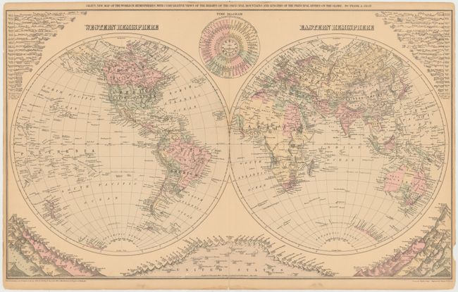
Title:
“Gray's New Map of the World in Hemispheres, with Comparative Views of the Heights of the Principal Mountains and Lengths of the Principal Rivers on the Globe”
Map Maker:
Frank Arnold Gray
This double-hemisphere world map delineates bounda... (full text available to subscribers)
| Item Detail |
| |
| |
MapMaker: |
Frank Arnold Gray
|
|
| |
| |
Subject: |
World |
|
| |
Period/Size: |
1879 / 15.8" x 26.3" (40.2 x 66.8 cm)
|
|
| |
Color: |
Colored
|
|
| |
Condition: |
(B+) Original color with light toning, a few minor spots, and a chip in right blank margin. There are a couple of centerfold separations and a 1/2" tear near center that have all been closed on verso with archival tape. (condition help) |
|
| |
Source: |
|
|
| |
References: |
|
|
| |
|
|
| Sales Information |
| |
| |
Price: |
|
|
| |
| |
Offered by: |
Old World Auctions |
|
| |
Catalog: |
Auction No. 144 - Antique Maps, Charts, Atlases & Globes (9203) |
|
| |
Lot/Item #: |
15 |
|
| |
| |
Date: |
04/2013
|
|
| |
| |
|
Antique Maps - Valuation and Pricing, Descriptions, Resources |
|
Home |
Information |
Search |
Register |
Contact Us |
Site Map
Americana Exchange, Inc. © 1999 - 2024 Americana Exchange, Inc.. All rights reserved.
OldMaps.com, the OldMaps.com logo and
AMPR are service marks or registered service marks of Americana Exchange, Inc..
|