Title:
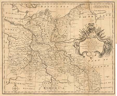
“A Correct Map of the North East part of Germany, Containing the Electorates of Saxony & Brandenburg, and the Duchies of Silesia, Mecklenburg, Pomerania & c.”
Map Maker:
Emanuel Bowen
Handsome and detailed map showing roads, forests, ... (full text available to subscribers)
| Item Detail |
| |
| |
MapMaker: |
Emanuel Bowen
|
|
| |
| |
Subject: |
Germany |
|
| |
Period/Size: |
1733 / 13.5" x 16.5" (34.3 x 42.0 cm)
|
|
| |
Color: |
Black & White
|
|
| |
Condition: |
(B) Issued folding with slight toning along folds and some light foxing. Closely trimmed at lower right for binding. (condition help) |
|
| |
Source: |
Tindal's Continuation of Rapin's History of England |
|
| |
References: |
|
|
| |
|
|
| Sales Information |
| |
| |
Price: |
|
|
| |
| |
Offered by: |
Old World Auctions |
|
| |
Catalog: |
Auction No. 96 - Antique Maps, Charts, Atlases & Globes (168) |
|
| |
Lot/Item #: |
328 |
|
| |
| |
Date: |
09/2001
|
|
| |
| |
|
Antique Maps - Valuation and Pricing, Descriptions, Resources |
|
Home |
Information |
Search |
Register |
Contact Us |
Site Map
Americana Exchange, Inc. © 1999 - 2024 Americana Exchange, Inc.. All rights reserved.
OldMaps.com, the OldMaps.com logo and
AMPR are service marks or registered service marks of Americana Exchange, Inc..
|