Title:
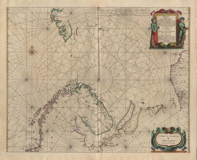
“Pascaart Vande Zee-Custen. Van Finmarcken, Laplant, Ruslant, Nova Zembla en Spitsbergen, hoe alle Havens, Rivieren en Droogten van malcanderen in hare courssen en distantien gelegen zyyn, alles op haer rechte situatie geleyt, ..”
Map Maker:
Jan Jansson
Handsome sea chart of the Barents Sea. The coastl... (full text available to subscribers)
| Item Detail |
| |
| |
MapMaker: |
Jan Jansson
|
|
| |
| |
Subject: |
Northern Europe |
|
| |
Period/Size: |
1650 / 17.1" x 21.6" (43.5 x 54.9 cm)
|
|
| |
Color: |
Colored
|
|
| |
Condition: |
(A) Superb original color. (condition help) |
|
| |
Source: |
|
|
| |
References: |
|
|
| |
|
|
| Sales Information |
| |
| |
Price: |
|
|
| |
| |
Offered by: |
Old World Auctions |
|
| |
Catalog: |
Auction No. 96 - Antique Maps, Charts, Atlases & Globes (168) |
|
| |
Lot/Item #: |
267 |
|
| |
| |
Date: |
09/2001
|
|
| |
| |
|
Antique Maps - Valuation and Pricing, Descriptions, Resources |
|
Home |
Information |
Search |
Register |
Contact Us |
Site Map
Americana Exchange, Inc. © 1999 - 2024 Americana Exchange, Inc.. All rights reserved.
OldMaps.com, the OldMaps.com logo and
AMPR are service marks or registered service marks of Americana Exchange, Inc..
|