Title:
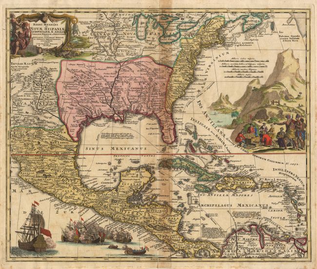
“Regni Mexicani Seu Novae Hispaniae, Ludovicianae, N. Angliae, Carolinae, Virginiae, et Pennsylvaniae nec non Insularum Archipelagi Mexicani in America Septentrionali accurata Tabula”
Map Maker:
Johann Baptist Homann
Magnificent, decorative map covering from the Grea... (full text available to subscribers)
| Item Detail |
| |
| |
MapMaker: |
Johann Baptist Homann
|
|
| |
| |
Subject: |
Colonial North America and West Indies |
|
| |
Period/Size: |
1746 / 18.7" x 22.5" (47.5 x 57.2 cm)
|
|
| |
Color: |
Colored
|
|
| |
Condition: |
(B) A crisp, bright impression on thick hand-laid paper with watermark. Acid burn along centerfold and a little foxing in margins. Clean split at lower centerfold, just touching neatline. (condition help) |
|
| |
Source: |
|
|
| |
References: |
Van Ermen p.42, Cumming (Southeast) #137, Martin & Martin plt.17. |
|
| |
|
|
| Sales Information |
| |
| |
Price: |
|
|
| |
| |
Offered by: |
Old World Auctions |
|
| |
Catalog: |
Auction No. 96 - Antique Maps, Charts, Atlases & Globes (168) |
|
| |
Lot/Item #: |
108 |
|
| |
| |
Date: |
09/2001
|
|
| |
| |
|
Antique Maps - Valuation and Pricing, Descriptions, Resources |
|
Home |
Information |
Search |
Register |
Contact Us |
Site Map
Americana Exchange, Inc. © 1999 - 2024 Americana Exchange, Inc.. All rights reserved.
OldMaps.com, the OldMaps.com logo and
AMPR are service marks or registered service marks of Americana Exchange, Inc..
|