| Item Detail |
| |
| |
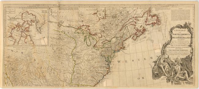
MapMaker: |
Robert Sayer
|
|
| |
| |
Subject: |
Eastern Canada & United States |
|
| |
Period/Size: |
1783 / 20.1" x 46.3" (51.1 x 117.6 cm)
|
|
| |
Color: |
Colored
|
|
| |
Condition: |
(C) There is offsetting and light soiling, and several fold separations that have been archivally repaired. Two long vertical tears to the right of the inset have been closed on verso with old paper. A previous owner stamped the recto in three locations (condition help) |
|
| |
Source: |
|
|
| |
References: |
Stevens & Tree (MCC-39) #49-j. |
|
| |
|
|
| Sales Information |
| |
| |
Price: |
|
|
| |
| |
Offered by: |
Old World Auctions |
|
| |
Catalog: |
Auction No. 145 - Antique Maps, Charts, Atlases & Globes (9224) |
|
| |
Lot/Item #: |
138 |
|
| |
| |
Date: |
06/2013
|
|
| |
| |
|