Title:
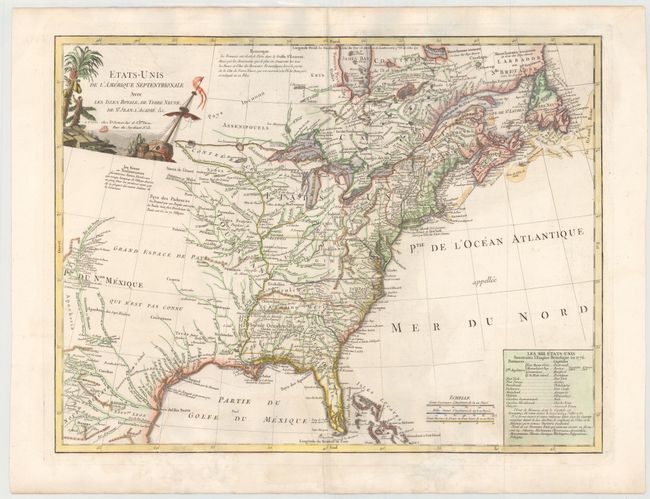
“Etats-Unis de l'Amerique Septentrionale avec les Isles Royale, de Terre Neuve, de St. Jean, l'Acadie &c.”
Map Maker:
Charles Francois Delamarche
This handsome map covers the newly created United ... (full text available to subscribers)
| Item Detail |
| |
| |
MapMaker: |
Charles Francois Delamarche
|
|
| |
| |
Subject: |
Eastern Canada & United States |
|
| |
Period/Size: |
1785 / 18.7" x 24.6" (47.5 x 62.5 cm)
|
|
| |
Color: |
Colored
|
|
| |
Condition: |
(B+) Watermarked paper with wide, original margins and light soiling. There are faint damp stains at bottom, with archival repairs to some paper weakness in bottom blank margin. (condition help) |
|
| |
Source: |
|
|
| |
References: |
Karpinski (MI) pp. 179-180, #CIII; McCorkle #785.5; Seller & Van Ee #187. |
|
| |
|
|
| Sales Information |
| |
| |
Price: |
|
|
| |
| |
Offered by: |
Old World Auctions |
|
| |
Catalog: |
Auction No. 145 - Antique Maps, Charts, Atlases & Globes (9224) |
|
| |
Lot/Item #: |
139 |
|
| |
| |
Date: |
06/2013
|
|
| |
| |
|
Antique Maps - Valuation and Pricing, Descriptions, Resources |
|
Home |
Information |
Search |
Register |
Contact Us |
Site Map
Americana Exchange, Inc. © 1999 - 2024 Americana Exchange, Inc.. All rights reserved.
OldMaps.com, the OldMaps.com logo and
AMPR are service marks or registered service marks of Americana Exchange, Inc..
|