Title:
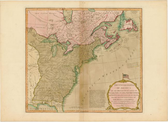
“The United States of America with the British Possessions of Canada, Nova Scotia, New Brunswick and Newfoundland Divided with the French, also the Spanish Territories of Louisiana and Florida According to the Preliminary Articles of Peace…”
Map Maker:
Laurie & Whittle
This map had a long publication history. It was p... (full text available to subscribers)
| Item Detail |
| |
| |
MapMaker: |
Laurie & Whittle
|
|
| |
| |
Subject: |
Eastern Canada & United States |
|
| |
Period/Size: |
1794 / 18.0" x 19.8" (45.8 x 50.3 cm)
|
|
| |
Color: |
Colored
|
|
| |
Condition: |
(B) Original color with wide margins, minor offsetting, and toning along centerfold. A couple of centerfold separations have been archivally repaired. (condition help) |
|
| |
Source: |
|
|
| |
References: |
McCorkle #755.2; Stevens & Tree (MCC-39) #51-e. |
|
| |
|
|
| Sales Information |
| |
| |
Price: |
|
|
| |
| |
Offered by: |
Old World Auctions |
|
| |
Catalog: |
Auction No. 145 - Antique Maps, Charts, Atlases & Globes (9224) |
|
| |
Lot/Item #: |
140 |
|
| |
| |
Date: |
06/2013
|
|
| |
| |
|
Antique Maps - Valuation and Pricing, Descriptions, Resources |
|
Home |
Information |
Search |
Register |
Contact Us |
Site Map
Americana Exchange, Inc. © 1999 - 2024 Americana Exchange, Inc.. All rights reserved.
OldMaps.com, the OldMaps.com logo and
AMPR are service marks or registered service marks of Americana Exchange, Inc..
|