Title:
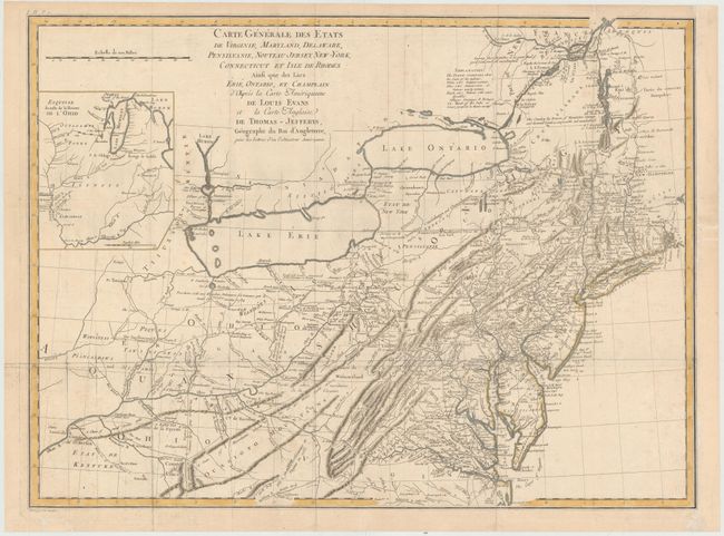
“Carte Generale des Etats de Virginie, Maryland, Delaware, Pensilvanie, Nouveau-Jersey, New-York, Connecticut et Isle de Rhodes Ainsi que des Lacs Erie, Ontario, et Champlain…”
Map Maker:
Michel Guillaume St. Jean de Crevecoeur
This is an updated French edition of Evans' rare a... (full text available to subscribers)
| Item Detail |
| |
| |
MapMaker: |
Michel Guillaume St. Jean de Crevecoeur
|
|
| |
| |
Subject: |
Eastern United States |
|
| |
Period/Size: |
1787 / 18.8" x 25.5" (47.8 x 64.8 cm)
|
|
| |
Color: |
Colored
|
|
| |
Condition: |
(B+) Issued folding and now flattened on watermarked paper with a few edge chips and tears confined to the blank margins repaired on verso with archival material and light printer's ink residue. Professionally remargined at right to better accommodate fr (condition help) |
|
| |
Source: |
Lettres d'un Cultivateur Americain |
|
| |
References: |
McCorkle #787.6; cf. Schwartz/Ehrenberg, p.162, pl. 98. |
|
| |
|
|
| Sales Information |
| |
| |
Price: |
|
|
| |
| |
Offered by: |
Old World Auctions |
|
| |
Catalog: |
Auction No. 145 - Antique Maps, Charts, Atlases & Globes (9224) |
|
| |
Lot/Item #: |
155 |
|
| |
| |
Date: |
06/2013
|
|
| |
| |
|
Antique Maps - Valuation and Pricing, Descriptions, Resources |
|
Home |
Information |
Search |
Register |
Contact Us |
Site Map
Americana Exchange, Inc. © 1999 - 2024 Americana Exchange, Inc.. All rights reserved.
OldMaps.com, the OldMaps.com logo and
AMPR are service marks or registered service marks of Americana Exchange, Inc..
|