Title:
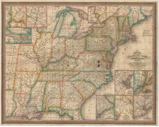
“Mitchell's Travellers Guide through the United States. A Map of the Roads, Distances, Steam Boat & Canal Routes &c.”
Map Maker:
Samuel Augustus Mitchell
This fine pocket map shows the United States west ... (full text available to subscribers)
| Item Detail |
| |
| |
MapMaker: |
Samuel Augustus Mitchell
|
|
| |
| |
Subject: |
Eastern United States |
|
| |
Period/Size: |
1832 / 17.3" x 21.8" (44.0 x 55.4 cm)
|
|
| |
Color: |
Colored
|
|
| |
Condition: |
(C+) Issued folding and now flattened and backed in tissue to reinforce and repair numerous fold separations resulting in minor loss at fold intersections. There are a few stains in Virginia and Kentucky, and smaller stains in the insets at bottom. Enca (condition help) |
|
| |
Source: |
|
|
| |
References: |
Ristow, p. 304. |
|
| |
|
|
| Sales Information |
| |
| |
Price: |
|
|
| |
| |
Offered by: |
Old World Auctions |
|
| |
Catalog: |
Auction No. 145 - Antique Maps, Charts, Atlases & Globes (9224) |
|
| |
Lot/Item #: |
163 |
|
| |
| |
Date: |
06/2013
|
|
| |
| |
|
Antique Maps - Valuation and Pricing, Descriptions, Resources |
|
Home |
Information |
Search |
Register |
Contact Us |
Site Map
Americana Exchange, Inc. © 1999 - 2024 Americana Exchange, Inc.. All rights reserved.
OldMaps.com, the OldMaps.com logo and
AMPR are service marks or registered service marks of Americana Exchange, Inc..
|