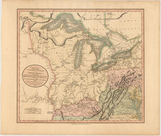
Title:
“A New Map of Part of the United States of North America, Exhibiting the Western Territory, Kentucky, Pennsylvania, Maryland, Virginia &c. Also, the Lakes Superior, Michigan, Huron, Ontario & Erie; with Upper and Lower Canada &c.”
Map Maker:
John Cary
This map shows the early frontier during a period ... (full text available to subscribers)
| Item Detail |
| |
| |
MapMaker: |
John Cary
|
|
| |
| |
Subject: |
Central United States, Great Lakes |
|
| |
Period/Size: |
1805 / 18.0" x 20.3" (45.8 x 51.6 cm)
|
|
| |
Color: |
Colored
|
|
| |
Condition: |
(A) Lovely original color on sturdy paper with a few tiny spots in the image. (condition help) |
|
| |
Source: |
New Universal Atlas |
|
| |
References: |
Phillips (Maps) p. 875; Manasek #93. |
|
| |
|
|
| Sales Information |
| |
| |
Price: |
|
|
| |
| |
Offered by: |
Old World Auctions |
|
| |
Catalog: |
Auction No. 145 - Antique Maps, Charts, Atlases & Globes (9224) |
|
| |
Lot/Item #: |
208 |
|
| |
| |
Date: |
06/2013
|
|
| |
| |
|
Antique Maps - Valuation and Pricing, Descriptions, Resources |
|
Home |
Information |
Search |
Register |
Contact Us |
Site Map
Americana Exchange, Inc. © 1999 - 2024 Americana Exchange, Inc.. All rights reserved.
OldMaps.com, the OldMaps.com logo and
AMPR are service marks or registered service marks of Americana Exchange, Inc..
|