Title:
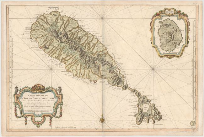
“Carte Reduite de l'Isle de Saint Christophe, Dressee au Depost des Cartes Plans et Journaux de la Marine...”
Map Maker:
Jacques Nicolas Bellin
Superb large-scale sea chart of St. Kitts vividly ... (full text available to subscribers)
| Item Detail |
| |
| |
MapMaker: |
Jacques Nicolas Bellin
|
|
| |
| |
Subject: |
St. Kitts |
|
| |
Period/Size: |
1758 / 23.2" x 34.6" (59.0 x 87.9 cm)
|
|
| |
Color: |
Colored
|
|
| |
Condition: |
(B+) Sturdy, watermarked paper with a hint of toning along centerfold and light soiling. (condition help) |
|
| |
Source: |
Hydrographie Francoise… |
|
| |
References: |
Tooley (MCC-81) St. Kitts #32, plt. 5. |
|
| |
|
|
| Sales Information |
| |
| |
Price: |
|
|
| |
| |
Offered by: |
Old World Auctions |
|
| |
Catalog: |
Auction No. 145 - Antique Maps, Charts, Atlases & Globes (9224) |
|
| |
Lot/Item #: |
361 |
|
| |
| |
Date: |
06/2013
|
|
| |
| |
|
Antique Maps - Valuation and Pricing, Descriptions, Resources |
|
Home |
Information |
Search |
Register |
Contact Us |
Site Map
Americana Exchange, Inc. © 1999 - 2024 Americana Exchange, Inc.. All rights reserved.
OldMaps.com, the OldMaps.com logo and
AMPR are service marks or registered service marks of Americana Exchange, Inc..
|