Title:
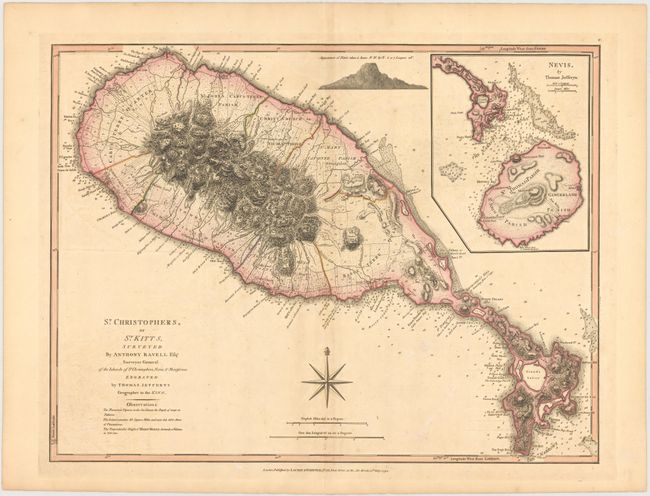
“St. Christophers, or St. Kitts, Surveyed by Anthony Ravell Esqr. Surveyor General of the Islands of St Christophers, Nevis, & Montserrat”
Map Maker:
Jefferys/Laurie & Whittle
This handsome large-scale map of St. Kitts has num... (full text available to subscribers)
| Item Detail |
| |
| |
MapMaker: |
Jefferys/Laurie & Whittle
|
|
| |
| |
Subject: |
St. Kitts & Nevis |
|
| |
Period/Size: |
1794 / 18.3" x 24.2" (46.5 x 61.5 cm)
|
|
| |
Color: |
Colored
|
|
| |
Condition: |
(B+) Very light toning and offsetting with a few minor spots of foxing. (condition help) |
|
| |
Source: |
|
|
| |
References: |
Tooley (MCC-81) St. Christopher #44; Sellers & Van Ee #1989. |
|
| |
|
|
| Sales Information |
| |
| |
Price: |
|
|
| |
| |
Offered by: |
Old World Auctions |
|
| |
Catalog: |
Auction No. 145 - Antique Maps, Charts, Atlases & Globes (9224) |
|
| |
Lot/Item #: |
363 |
|
| |
| |
Date: |
06/2013
|
|
| |
| |
|
Antique Maps - Valuation and Pricing, Descriptions, Resources |
|
Home |
Information |
Search |
Register |
Contact Us |
Site Map
Americana Exchange, Inc. © 1999 - 2024 Americana Exchange, Inc.. All rights reserved.
OldMaps.com, the OldMaps.com logo and
AMPR are service marks or registered service marks of Americana Exchange, Inc..
|