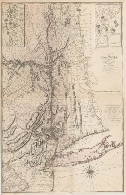
Title:
“A Map of the Province of New York, with Part of Pensilvania, and New England…”
Map Maker:
John Montresor
This map, issued during the
Revolutionary War
| Item Detail |
| |
| |
MapMaker: |
John Montresor
|
|
| |
| |
Subject: |
Colonial New England & Mid-Atlantic |
|
| |
Period/Size: |
1775 / 28.5" x 36.2" (72.4 x 92.0 cm)
|
|
| |
Color: |
Colored
|
|
| |
Condition: |
(A) A fine impression on watermarked paper. There is light soiling on bottom left sheet and a professionally repaired fold separation on Staten Island. (condition help) |
|
| |
Source: |
|
|
| |
References: |
Pritchard & Taliaferro #45; McCorkle #775.9, Sellers & van Ee #1066; Stevens & Tree #42(b). |
|
| |
|
|
| Sales Information |
| |
| |
Price: |
|
|
| |
| |
Offered by: |
Old World Auctions |
|
| |
Catalog: |
Auction No. 146 - Antique Maps, Charts, Atlases & Globes (9225) |
|
| |
Lot/Item #: |
161 |
|
| |
| |
Date: |
09/2013
|
|
| |
| |
|
Antique Maps - Valuation and Pricing, Descriptions, Resources |
|
Home |
Information |
Search |
Register |
Contact Us |
Site Map
Americana Exchange, Inc. © 1999 - 2024 Americana Exchange, Inc.. All rights reserved.
OldMaps.com, the OldMaps.com logo and
AMPR are service marks or registered service marks of Americana Exchange, Inc..
|