Title:
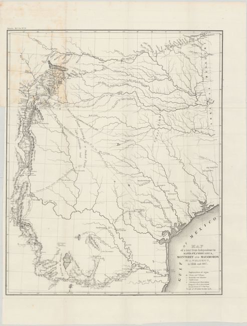
“Map of a Tour from Independence to Santa Fe, Chihuahua, Monterey and Matamoros”
Map Maker:
Frederick Adolphus Wislizenus
This is a fascinating map of the early state of T... (full text available to subscribers)
| Item Detail |
| |
| |
MapMaker: |
Frederick Adolphus Wislizenus
|
|
| |
| |
Subject: |
Texas |
|
| |
Period/Size: |
1848 / 19.6" x 16.0" (49.8 x 40.7 cm)
|
|
| |
Color: |
Black & White
|
|
| |
Condition: |
(B+) Issued folding with a binding trim at left and an associated 1" binding tear that is closed on verso with archival tape. Light foxing at upper left where the map folded into the report. (condition help) |
|
| |
Source: |
|
|
| |
References: |
Wheat (TMW) #572. |
|
| |
|
|
| Sales Information |
| |
| |
Price: |
|
|
| |
| |
Offered by: |
Old World Auctions |
|
| |
Catalog: |
Auction No. 146 - Antique Maps, Charts, Atlases & Globes (9225) |
|
| |
Lot/Item #: |
260 |
|
| |
| |
Date: |
09/2013
|
|
| |
| |
|
Antique Maps - Valuation and Pricing, Descriptions, Resources |
|
Home |
Information |
Search |
Register |
Contact Us |
Site Map
Americana Exchange, Inc. © 1999 - 2024 Americana Exchange, Inc.. All rights reserved.
OldMaps.com, the OldMaps.com logo and
AMPR are service marks or registered service marks of Americana Exchange, Inc..
|