Title:
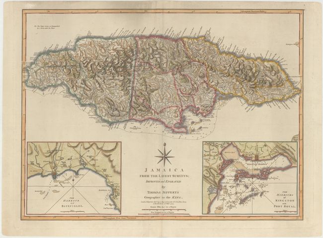
“Jamaica from the Latest Surveys”
Map Maker:
Jefferys/Sayer
This detailed map of Jamaica shows the parishes, t... (full text available to subscribers)
| Item Detail |
| |
| |
MapMaker: |
Jefferys/Sayer
|
|
| |
| |
Subject: |
Jamaica |
|
| |
Period/Size: |
1775 / 18.4" x 24.4" (46.8 x 62.0 cm)
|
|
| |
Color: |
Colored
|
|
| |
Condition: |
(B+) A nice impression on watermarked paper with light soiling at top and a printer's crease at top left that has been reinforced with archival material. (condition help) |
|
| |
Source: |
The West Indian Atlas |
|
| |
References: |
Kapp (MCC-42) #101; Sellers & Van Ee #1930; Shirley (BL Atlases) M.JEF-4a #24. |
|
| |
|
|
| Sales Information |
| |
| |
Price: |
|
|
| |
| |
Offered by: |
Old World Auctions |
|
| |
Catalog: |
Auction No. 146 - Antique Maps, Charts, Atlases & Globes (9225) |
|
| |
Lot/Item #: |
310 |
|
| |
| |
Date: |
09/2013
|
|
| |
| |
|
Antique Maps - Valuation and Pricing, Descriptions, Resources |
|
Home |
Information |
Search |
Register |
Contact Us |
Site Map
Americana Exchange, Inc. © 1999 - 2024 Americana Exchange, Inc.. All rights reserved.
OldMaps.com, the OldMaps.com logo and
AMPR are service marks or registered service marks of Americana Exchange, Inc..
|