Title:
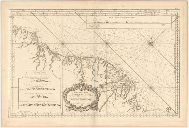
“Carte Reduite des Costes de la Guyane depuis la Riviere d'Orenoque jusqu'au Cap de Nord a l'Entree de la Riviere des Amazones…”
Map Maker:
Jacques Nicolas Bellin
This magnificent, large-scale map of the coast of ... (full text available to subscribers)
| Item Detail |
| |
| |
MapMaker: |
Jacques Nicolas Bellin
|
|
| |
| |
Subject: |
Guyana, Suriname, French Guiana |
|
| |
Period/Size: |
1760 / 22.0" x 34.1" (55.9 x 86.7 cm)
|
|
| |
Color: |
Black & White
|
|
| |
Condition: |
(B+) Heavy paper with large watermarks dated "1782." There is light offsetting and a few tiny spots. (condition help) |
|
| |
Source: |
|
|
| |
References: |
|
|
| |
|
|
| Sales Information |
| |
| |
Price: |
|
|
| |
| |
Offered by: |
Old World Auctions |
|
| |
Catalog: |
Auction No. 146 - Antique Maps, Charts, Atlases & Globes (9225) |
|
| |
Lot/Item #: |
340 |
|
| |
| |
Date: |
09/2013
|
|
| |
| |
|
Antique Maps - Valuation and Pricing, Descriptions, Resources |
|
Home |
Information |
Search |
Register |
Contact Us |
Site Map
Americana Exchange, Inc. © 1999 - 2024 Americana Exchange, Inc.. All rights reserved.
OldMaps.com, the OldMaps.com logo and
AMPR are service marks or registered service marks of Americana Exchange, Inc..
|