Title:
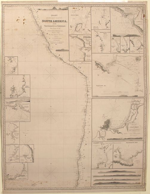
“Chart of the West Coast of South America, from Valparaiso to Truxillo, with Plans of the Principal Harbours, Chiefly from the Late English Surveys, Drawn by J. S. Hobbs, E.R.G.S. Hydrographer”
Map Maker:
John William Norie
This impressive blueback chart depicts the coastli... (full text available to subscribers)
| Item Detail |
| |
| |
MapMaker: |
John William Norie
|
|
| |
| |
Subject: |
Western South America |
|
| |
Period/Size: |
1857 / 48.0" x 37.0" (122.0 x 94.0 cm)
|
|
| |
Color: |
Black & White
|
|
| |
Condition: |
(B) There are a few tiny abrasions and some small stains at top and bottom, otherwise the chart is fairly clean. One tear that enters 1" into chart at upper left has been closed on verso with the blue backing. Overall in good condition for a working cha (condition help) |
|
| |
Source: |
|
|
| |
References: |
|
|
| |
|
|
| Sales Information |
| |
| |
Price: |
|
|
| |
| |
Offered by: |
Old World Auctions |
|
| |
Catalog: |
Auction No. 146 - Antique Maps, Charts, Atlases & Globes (9225) |
|
| |
Lot/Item #: |
361 |
|
| |
| |
Date: |
09/2013
|
|
| |
| |
|
Antique Maps - Valuation and Pricing, Descriptions, Resources |
|
Home |
Information |
Search |
Register |
Contact Us |
Site Map
Americana Exchange, Inc. © 1999 - 2024 Americana Exchange, Inc.. All rights reserved.
OldMaps.com, the OldMaps.com logo and
AMPR are service marks or registered service marks of Americana Exchange, Inc..
|