Title:
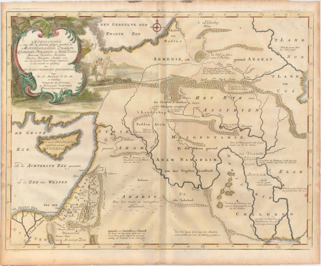
“Afbeelding van Alle de Landen Gelegen Tusschen de Middelandische, Zwarte, Caspische, Persische en Rode Zeen…”
Map Maker:
Willem Albert Bachiene
This uncommon map covers the region from the Cauca... (full text available to subscribers)
| Item Detail |
| |
| |
MapMaker: |
Willem Albert Bachiene
|
|
| |
| |
Subject: |
Middle East |
|
| |
Period/Size: |
1748 / 15.5" x 20.0" (39.4 x 50.8 cm)
|
|
| |
Color: |
Colored
|
|
| |
Condition: |
(A) Watermarked paper with a couple of insignificant spots and light toning along sheet edges. (condition help) |
|
| |
Source: |
|
|
| |
References: |
Laor #66; Poortman & Augusteijn #176. |
|
| |
|
|
| Sales Information |
| |
| |
Price: |
|
|
| |
| |
Offered by: |
Old World Auctions |
|
| |
Catalog: |
Auction No. 146 - Antique Maps, Charts, Atlases & Globes (9225) |
|
| |
Lot/Item #: |
630 |
|
| |
| |
Date: |
09/2013
|
|
| |
| |
|
Antique Maps - Valuation and Pricing, Descriptions, Resources |
|
Home |
Information |
Search |
Register |
Contact Us |
Site Map
Americana Exchange, Inc. © 1999 - 2024 Americana Exchange, Inc.. All rights reserved.
OldMaps.com, the OldMaps.com logo and
AMPR are service marks or registered service marks of Americana Exchange, Inc..
|