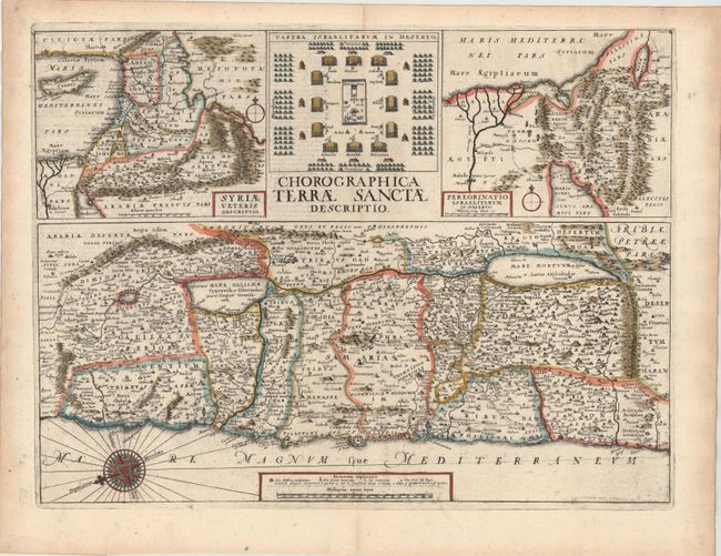
Title:
“Chorographica Terrae Sanctae Descriptio”
Map Maker:
Wenceslaus Hollar
This sheet includes three maps of the Holy Land an... (full text available to subscribers)
| Item Detail |
| |
| |
MapMaker: |
Wenceslaus Hollar
|
|
| |
| |
Subject: |
Holy Land |
|
| |
Period/Size: |
1657 / 14.7" x 19.4" (37.4 x 49.3 cm)
|
|
| |
Color: |
Colored
|
|
| |
Condition: |
(B+) Watermarked paper with some printer's ink residue and two tiny holes that have been professionally infilled. (condition help) |
|
| |
Source: |
Biblia Sacra Polyglotta… |
|
| |
References: |
Laor #339. |
|
| |
|
|
| Sales Information |
| |
| |
Price: |
|
|
| |
| |
Offered by: |
Old World Auctions |
|
| |
Catalog: |
Auction No. 146 - Antique Maps, Charts, Atlases & Globes (9225) |
|
| |
Lot/Item #: |
647 |
|
| |
| |
Date: |
09/2013
|
|
| |
| |
|
Antique Maps - Valuation and Pricing, Descriptions, Resources |
|
Home |
Information |
Search |
Register |
Contact Us |
Site Map
Americana Exchange, Inc. © 1999 - 2024 Americana Exchange, Inc.. All rights reserved.
OldMaps.com, the OldMaps.com logo and
AMPR are service marks or registered service marks of Americana Exchange, Inc..
|