Title:
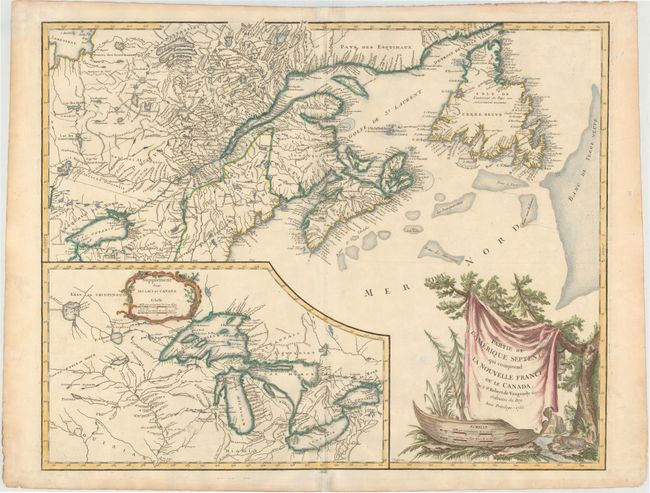
“Partie de l'Amerique Septent? qui Comprend la Nouvelle France ou le Canada”
Map Maker:
Robert de Vaugondy [Family]
This is a handsome map of Newfoundland, Nova Scoti... (full text available to subscribers)
| Item Detail |
| |
| |
MapMaker: |
Robert de Vaugondy [Family]
|
|
| |
| |
Subject: |
Colonial United States & Canada, Great Lakes |
|
| |
Period/Size: |
1755 / 18.5" x 23.5" (47.0 x 59.7 cm)
|
|
| |
Color: |
Colored
|
|
| |
Condition: |
(B+) On heavy watermarked paper with small centerfold separations at top and bottom repaired with archival material. There are two tiny holes in unengraved areas that have been professionally infilled. (condition help) |
|
| |
Source: |
Atlas Universel |
|
| |
References: |
Kershaw #355; Pedley #459; Sellers and Van Ee #61. |
|
| |
|
|
| Sales Information |
| |
| |
Price: |
|
|
| |
| |
Offered by: |
Old World Auctions |
|
| |
Catalog: |
Auction No. 147 - Antique Maps, Charts, Atlases & Globes (9226) |
|
| |
Lot/Item #: |
113 |
|
| |
| |
Date: |
11/2013
|
|
| |
| |
|
Antique Maps - Valuation and Pricing, Descriptions, Resources |
|
Home |
Information |
Search |
Register |
Contact Us |
Site Map
Americana Exchange, Inc. © 1999 - 2024 Americana Exchange, Inc.. All rights reserved.
OldMaps.com, the OldMaps.com logo and
AMPR are service marks or registered service marks of Americana Exchange, Inc..
|