Title:
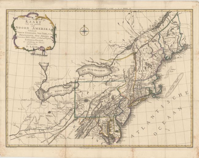
“Nieuwe en Nauwkeurige Kaart van een gedeelte van Noord Amerika, behelzende Nieuw Engeland, New York, Pensylvania, New Jersey, Connecticut, Rhode Island, een Stuk van Virginia, Kanada en Halifax”
Map Maker:
Pieter Kalm
This scarce map covers Virginia through New Englan... (full text available to subscribers)
| Item Detail |
| |
| |
MapMaker: |
Pieter Kalm
|
|
| |
| |
Subject: |
Colonial Northeastern United States |
|
| |
Period/Size: |
1772 / 22.0" x 29.9" (55.9 x 76.0 cm)
|
|
| |
Color: |
Colored
|
|
| |
Condition: |
(B+) A sharp impression with a few unobtrusive spots. Issued folding and now flattened with a couple expert repairs on minor fold separations. There is a small printer’s ink smudge in the Atlantic Ocean. (condition help) |
|
| |
Source: |
Reis door Noord Amerika |
|
| |
References: |
McCorkle #772.3; Seller & Van Ee #727; Howes #K5. |
|
| |
|
|
| Sales Information |
| |
| |
Price: |
|
|
| |
| |
Offered by: |
Old World Auctions |
|
| |
Catalog: |
Auction No. 147 - Antique Maps, Charts, Atlases & Globes (9226) |
|
| |
Lot/Item #: |
137 |
|
| |
| |
Date: |
11/2013
|
|
| |
| |
|
Antique Maps - Valuation and Pricing, Descriptions, Resources |
|
Home |
Information |
Search |
Register |
Contact Us |
Site Map
Americana Exchange, Inc. © 1999 - 2024 Americana Exchange, Inc.. All rights reserved.
OldMaps.com, the OldMaps.com logo and
AMPR are service marks or registered service marks of Americana Exchange, Inc..
|