Title:
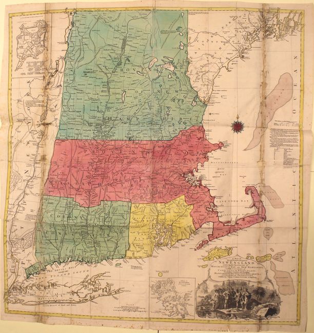
“A Map of the Most Inhabited Part of New England, Containing the Provinces of Massachusets Bay and New Hampshire, with the Colonies of Conecticut and Rhode Island…”
Map Maker:
Tobias Conrad Lotter
The title continues "Divided into Counties and Tow... (full text available to subscribers)
| Item Detail |
| |
| |
MapMaker: |
Tobias Conrad Lotter
|
|
| |
| |
Subject: |
Colonial New England |
|
| |
Period/Size: |
1776 / 40.2" x 38.0" (102.1 x 96.6 cm)
|
|
| |
Color: |
Colored
|
|
| |
Condition: |
(C+) A nice impression with original color on watermarked paper with minor foxing at bottom. There is toning and soiling along vertical folds at far right and far left, with numerous separations, tears, and holes along the folds that have been closed on (condition help) |
|
| |
Source: |
|
|
| |
References: |
McCorkle 776.16; Sellers & Van Ee #801; cf. Pritchard & Taliaferro #35. |
|
| |
|
|
| Sales Information |
| |
| |
Price: |
|
|
| |
| |
Offered by: |
Old World Auctions |
|
| |
Catalog: |
Auction No. 147 - Antique Maps, Charts, Atlases & Globes (9226) |
|
| |
Lot/Item #: |
150 |
|
| |
| |
Date: |
11/2013
|
|
| |
| |
|
Antique Maps - Valuation and Pricing, Descriptions, Resources |
|
Home |
Information |
Search |
Register |
Contact Us |
Site Map
Americana Exchange, Inc. © 1999 - 2024 Americana Exchange, Inc.. All rights reserved.
OldMaps.com, the OldMaps.com logo and
AMPR are service marks or registered service marks of Americana Exchange, Inc..
|