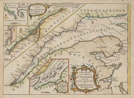
Title:
“A New Chart of the River St. Lawrence from the Island of Anticosti to Lake Ontario”
Map Maker:
Thomas Kitchin
Nice copper engraved map showing navigational cour... (full text available to subscribers)
| Item Detail |
| |
| |
MapMaker: |
Thomas Kitchin
|
|
| |
| |
Subject: |
Canada |
|
| |
Period/Size: |
1759 / 7.2" x 10.0" (18.3 x 25.4 cm)
|
|
| |
Color: |
Colored
|
|
| |
Condition: |
(B) Trimmed into neatline at binding side with paper laid in and neatline supplied in facsimile. (condition help) |
|
| |
Source: |
London Magazine |
|
| |
References: |
Jolly LOND-174. |
|
| |
|
|
| Sales Information |
| |
| |
Price: |
|
|
| |
| |
Offered by: |
Old World Auctions |
|
| |
Catalog: |
Auction No. 96 - Antique Maps, Charts, Atlases & Globes (168) |
|
| |
Lot/Item #: |
125 |
|
| |
| |
Date: |
09/2001
|
|
| |
| |
|
Antique Maps - Valuation and Pricing, Descriptions, Resources |
|
Home |
Information |
Search |
Register |
Contact Us |
Site Map
Americana Exchange, Inc. © 1999 - 2024 Americana Exchange, Inc.. All rights reserved.
OldMaps.com, the OldMaps.com logo and
AMPR are service marks or registered service marks of Americana Exchange, Inc..
|