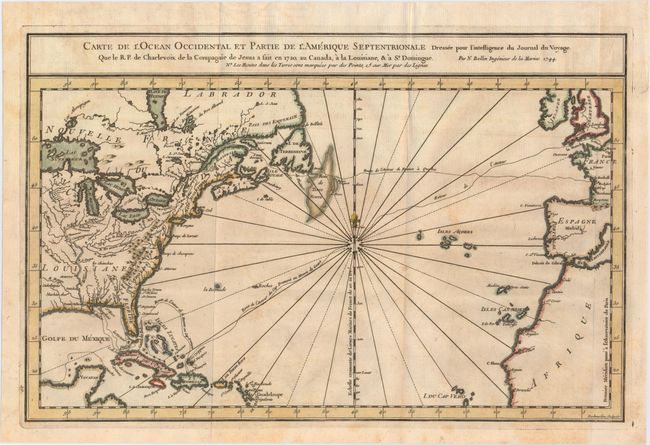
Title:
“Carte de l'Ocean Occidental et Partie de l'Amerique Septentrionale Dresse pour l'Intelligence du Journal du Voyage. Que le R.P. de Charlevoix de la Compagnie de Jesus a Fait en 1720...”
Map Maker:
Jacques Nicolas Bellin
Attractive chart of the Atlantic, from about 15° n... (full text available to subscribers)
| Item Detail |
| |
| |
MapMaker: |
Jacques Nicolas Bellin
|
|
| |
| |
Subject: |
North Atlantic, Colonial North America |
|
| |
Period/Size: |
1744 / 9.6" x 14.9" (24.4 x 37.9 cm)
|
|
| |
Color: |
Colored
|
|
| |
Condition: |
(B+) A strong impression issued folding on watermarked paper with faint toning and offsetting. (condition help) |
|
| |
Source: |
Charlevoix's Histoire et Description de la Nouvelle France |
|
| |
References: |
Tooley (MCC-96) #711. |
|
| |
|
|
| Sales Information |
| |
| |
Price: |
|
|
| |
| |
Offered by: |
Old World Auctions |
|
| |
Catalog: |
Auction No. 147 - Antique Maps, Charts, Atlases & Globes (9226) |
|
| |
Lot/Item #: |
374 |
|
| |
| |
Date: |
11/2013
|
|
| |
| |
|
Antique Maps - Valuation and Pricing, Descriptions, Resources |
|
Home |
Information |
Search |
Register |
Contact Us |
Site Map
Americana Exchange, Inc. © 1999 - 2024 Americana Exchange, Inc.. All rights reserved.
OldMaps.com, the OldMaps.com logo and
AMPR are service marks or registered service marks of Americana Exchange, Inc..
|