Title:
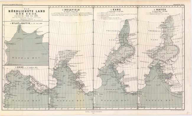
“Das Nordlichste Land der Erde, Entdeckt 1616 bis 1861”
Map Maker:
Augustus Heinrich Petermann
This unique map traces the history of exploration ... (full text available to subscribers)
| Item Detail |
| |
| |
MapMaker: |
Augustus Heinrich Petermann
|
|
| |
| |
Subject: |
Baffin Bay |
|
| |
Period/Size: |
1867 / 9.7" x 16.8" (24.7 x 42.7 cm)
|
|
| |
Color: |
Colored
|
|
| |
Condition: |
(A) Issued folding with faint toning along one of the folds. (condition help) |
|
| |
Source: |
Petermann's Geographische Mittheilungen |
|
| |
References: |
|
|
| |
|
|
| Sales Information |
| |
| |
Price: |
|
|
| |
| |
Offered by: |
Old World Auctions |
|
| |
Catalog: |
Auction No. 147 - Antique Maps, Charts, Atlases & Globes (9226) |
|
| |
Lot/Item #: |
378 |
|
| |
| |
Date: |
11/2013
|
|
| |
| |
|
Antique Maps - Valuation and Pricing, Descriptions, Resources |
|
Home |
Information |
Search |
Register |
Contact Us |
Site Map
Americana Exchange, Inc. © 1999 - 2024 Americana Exchange, Inc.. All rights reserved.
OldMaps.com, the OldMaps.com logo and
AMPR are service marks or registered service marks of Americana Exchange, Inc..
|