Title:
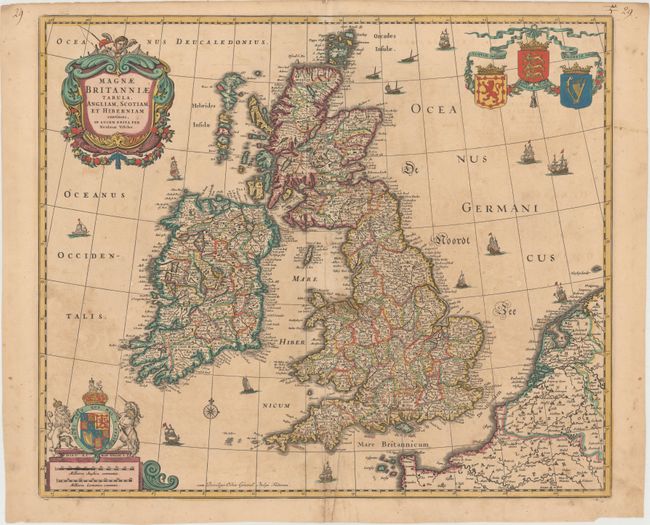
“Magnae Britanniae Tabula, Angliam, Scotiam, et Hiberniam Continens, in Lucem Edita”
Map Maker:
Nicolas Visscher
This spectacular map of the British Isles expands ... (full text available to subscribers)
| Item Detail |
| |
| |
MapMaker: |
Nicolas Visscher
|
|
| |
| |
Subject: |
Britain |
|
| |
Period/Size: |
1679 / 17.8" x 21.0" (45.3 x 53.4 cm)
|
|
| |
Color: |
Colored
|
|
| |
Condition: |
(B) Light toning. There are several small centerfold separations at bottom and two small abrasions in unengraved areas, all of which have been repaired with archival material on verso. (condition help) |
|
| |
Source: |
|
|
| |
References: |
Shirley (BI to 1750) Visscher 1, state 5. |
|
| |
|
|
| Sales Information |
| |
| |
Price: |
|
|
| |
| |
Offered by: |
Old World Auctions |
|
| |
Catalog: |
Auction No. 147 - Antique Maps, Charts, Atlases & Globes (9226) |
|
| |
Lot/Item #: |
394 |
|
| |
| |
Date: |
11/2013
|
|
| |
| |
|
Antique Maps - Valuation and Pricing, Descriptions, Resources |
|
Home |
Information |
Search |
Register |
Contact Us |
Site Map
Americana Exchange, Inc. © 1999 - 2024 Americana Exchange, Inc.. All rights reserved.
OldMaps.com, the OldMaps.com logo and
AMPR are service marks or registered service marks of Americana Exchange, Inc..
|