Title:
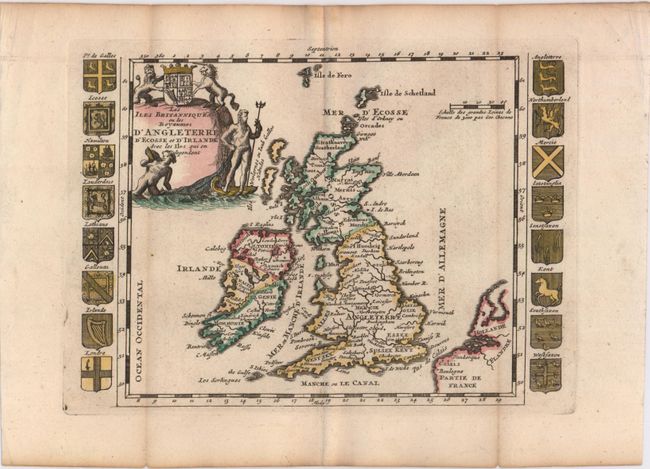
“Les Iles Britanniques ou les Royaumes d'Angleterre d'Ecosse et d'Irlande avec les Iles qui en Dependent”
Map Maker:
Daniel de La Feuille
Very handsome small map decorated with an interest... (full text available to subscribers)
| Item Detail |
| |
| |
MapMaker: |
Daniel de La Feuille
|
|
| |
| |
Subject: |
Britain |
|
| |
Period/Size: |
1706 / 6.3" x 8.7" (16.0 x 22.1 cm)
|
|
| |
Color: |
Colored
|
|
| |
Condition: |
(B+) Issued folding, now pressed with wide margins and very light toning along folds. (condition help) |
|
| |
Source: |
Les Tablettes Guerrieresģ |
|
| |
References: |
Shirley (BI to 1750) La Feuille 1. |
|
| |
|
|
| Sales Information |
| |
| |
Price: |
|
|
| |
| |
Offered by: |
Old World Auctions |
|
| |
Catalog: |
Auction No. 147 - Antique Maps, Charts, Atlases & Globes (9226) |
|
| |
Lot/Item #: |
396 |
|
| |
| |
Date: |
11/2013
|
|
| |
| |
|
Antique Maps - Valuation and Pricing, Descriptions, Resources |
|
Home |
Information |
Search |
Register |
Contact Us |
Site Map
Americana Exchange, Inc. © 1999 - 2024 Americana Exchange, Inc.. All rights reserved.
OldMaps.com, the OldMaps.com logo and
AMPR are service marks or registered service marks of Americana Exchange, Inc..
|