Title:
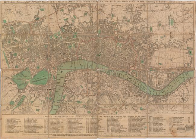
“Bowles's Reduced New Pocket Plan of the Cities of London and Westminster, with the Borough of Southwark, Exhibiting the New Buildings to 1798”
Map Maker:
Bowles & Carver
This very detailed map of London and vicinity was ... (full text available to subscribers)
| Item Detail |
| |
| |
MapMaker: |
Bowles & Carver
|
|
| |
| |
Subject: |
London, England |
|
| |
Period/Size: |
1798 / 15.0" x 21.6" (38.1 x 54.9 cm)
|
|
| |
Color: |
Colored
|
|
| |
Condition: |
(B) The linen has separated along several segments, but the map is still intact overall. Light toning with some soiling at bottom. Slip case is heavily worn, but also still intact. (condition help) |
|
| |
Source: |
|
|
| |
References: |
Howgego #168. |
|
| |
|
|
| Sales Information |
| |
| |
Price: |
|
|
| |
| |
Offered by: |
Old World Auctions |
|
| |
Catalog: |
Auction No. 147 - Antique Maps, Charts, Atlases & Globes (9226) |
|
| |
Lot/Item #: |
405 |
|
| |
| |
Date: |
11/2013
|
|
| |
| |
|
Antique Maps - Valuation and Pricing, Descriptions, Resources |
|
Home |
Information |
Search |
Register |
Contact Us |
Site Map
Americana Exchange, Inc. © 1999 - 2024 Americana Exchange, Inc.. All rights reserved.
OldMaps.com, the OldMaps.com logo and
AMPR are service marks or registered service marks of Americana Exchange, Inc..
|