Title:
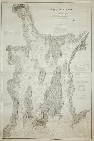
“Narragansett Bay. From a Trigonometrical Survey under the direction of Benjamin Peire Superintendent of the Survey of the Coast of the United States”
Map Maker:
U.S. Coast Survey
Extremely scarce original navigation chart issued ... (full text available to subscribers)
| Item Detail |
| |
| |
MapMaker: |
U.S. Coast Survey
|
|
| |
| |
Subject: |
Rhode Island |
|
| |
Period/Size: |
1873 / 45.5" x 30.0" (115.6 x 76.2 cm)
|
|
| |
Color: |
Black & White
|
|
| |
Condition: |
(A) There are a couple of spots of foxing and some chipping in the wide margins, but overall extremely good condition for a working sailing chart. (condition help) |
|
| |
Source: |
|
|
| |
References: |
|
|
| |
|
|
| Sales Information |
| |
| |
Price: |
|
|
| |
| |
Offered by: |
Old World Auctions |
|
| |
Catalog: |
Auction No. 96 - Antique Maps, Charts, Atlases & Globes (168) |
|
| |
Lot/Item #: |
191 |
|
| |
| |
Date: |
09/2001
|
|
| |
| |
|
Antique Maps - Valuation and Pricing, Descriptions, Resources |
|
Home |
Information |
Search |
Register |
Contact Us |
Site Map
Americana Exchange, Inc. © 1999 - 2024 Americana Exchange, Inc.. All rights reserved.
OldMaps.com, the OldMaps.com logo and
AMPR are service marks or registered service marks of Americana Exchange, Inc..
|