Title:
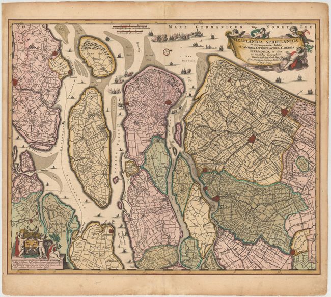
“Delflandia, Schielandia et Circumjacentes Insulae ut Voorna, Overflackea, Goerea, Yselmonda et Aliae, ex Conatibus Geographicis”
Map Maker:
Nicolas Visscher
This detailed road map shows the estuary of the Ri... (full text available to subscribers)
| Item Detail |
| |
| |
MapMaker: |
Nicolas Visscher
|
|
| |
| |
Subject: |
Southwestern Netherlands |
|
| |
Period/Size: |
1680 / 18.3" x 22.3" (46.5 x 56.7 cm)
|
|
| |
Color: |
Colored
|
|
| |
Condition: |
(B+) Lovely original color that has been partially refreshed, light soiling, professionally repaired centerfold separations at top and bottom, and faint damp stains that just enter map borders at right and left. (condition help) |
|
| |
Source: |
|
|
| |
References: |
|
|
| |
|
|
| Sales Information |
| |
| |
Price: |
|
|
| |
| |
Offered by: |
Old World Auctions |
|
| |
Catalog: |
Auction No. 147 - Antique Maps, Charts, Atlases & Globes (9226) |
|
| |
Lot/Item #: |
441 |
|
| |
| |
Date: |
11/2013
|
|
| |
| |
|
Antique Maps - Valuation and Pricing, Descriptions, Resources |
|
Home |
Information |
Search |
Register |
Contact Us |
Site Map
Americana Exchange, Inc. © 1999 - 2024 Americana Exchange, Inc.. All rights reserved.
OldMaps.com, the OldMaps.com logo and
AMPR are service marks or registered service marks of Americana Exchange, Inc..
|