Title:
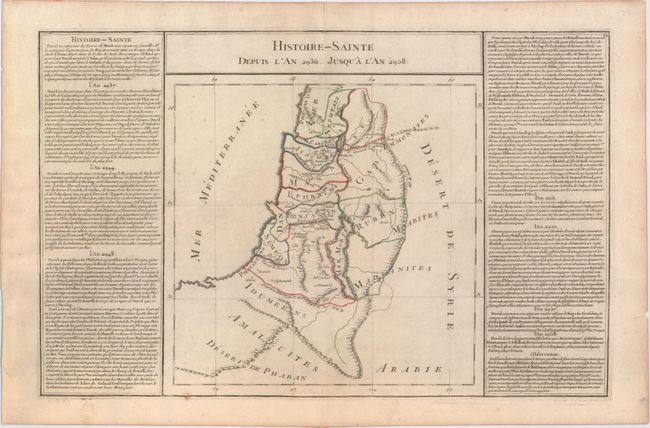
“Histoire-Sainte Depuis l'An 2936. Jusqu'a l'An 2958”
Map Maker:
Claude Buy de Mornas
This map of the Holy Land depicts the 12 tribes an... (full text available to subscribers)
| Item Detail |
| |
| |
MapMaker: |
Claude Buy de Mornas
|
|
| |
| |
Subject: |
Holy Land |
|
| |
Period/Size: |
1761 / 11.7" x 17.8" (29.8 x 45.3 cm)
|
|
| |
Color: |
Colored
|
|
| |
Condition: |
(B+) Original outline color on watermarked paper with a few small spots and an archivally repaired centerfold separation in top blank margin. (condition help) |
|
| |
Source: |
Atlas Methodique et Elementaire de Goegraphie et l'Histoire |
|
| |
References: |
|
|
| |
|
|
| Sales Information |
| |
| |
Price: |
|
|
| |
| |
Offered by: |
Old World Auctions |
|
| |
Catalog: |
Auction No. 147 - Antique Maps, Charts, Atlases & Globes (9226) |
|
| |
Lot/Item #: |
582 |
|
| |
| |
Date: |
11/2013
|
|
| |
| |
|
Antique Maps - Valuation and Pricing, Descriptions, Resources |
|
Home |
Information |
Search |
Register |
Contact Us |
Site Map
Americana Exchange, Inc. © 1999 - 2024 Americana Exchange, Inc.. All rights reserved.
OldMaps.com, the OldMaps.com logo and
AMPR are service marks or registered service marks of Americana Exchange, Inc..
|