Title:
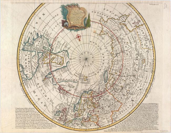
“A Correct Draught of the North Pole and of All the Countries Hitherto Discovered, Intercepted Between the Pole and the Parallel of 50 Degrees...”
Map Maker:
Emanuel Bowen
A highly detailed map that shows the tracks of nav... (full text available to subscribers)
| Item Detail |
| |
| |
MapMaker: |
Emanuel Bowen
|
|
| |
| |
Subject: |
North Pole |
|
| |
Period/Size: |
1744 / 15.4" x 17.2" (39.2 x 43.7 cm)
|
|
| |
Color: |
Colored
|
|
| |
Condition: |
(B+) A dark impression on watermarked paper with attractive color and two small stains to the right of the title cartouche. (condition help) |
|
| |
Source: |
Navigantium atque Itinerantium Bibliothecaģ |
|
| |
References: |
Kershaw #418. |
|
| |
|
|
| Sales Information |
| |
| |
Price: |
|
|
| |
| |
Offered by: |
Old World Auctions |
|
| |
Catalog: |
Auction No. 148 - Antique Maps, Charts, Atlases & Globes (9227) |
|
| |
Lot/Item #: |
46 |
|
| |
| |
Date: |
02/2014
|
|
| |
| |
|
Antique Maps - Valuation and Pricing, Descriptions, Resources |
|
Home |
Information |
Search |
Register |
Contact Us |
Site Map
Americana Exchange, Inc. © 1999 - 2024 Americana Exchange, Inc.. All rights reserved.
OldMaps.com, the OldMaps.com logo and
AMPR are service marks or registered service marks of Americana Exchange, Inc..
|