Title:
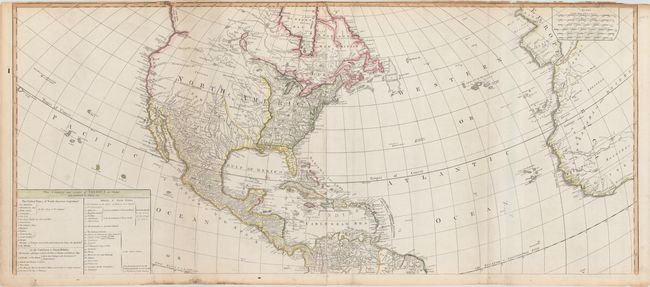
“A New Map of the Whole Continent of America, Divided into North and South and West Indies wherein are Exactly Described the United States of North America...”
Map Maker:
Laurie & Whittle
An impressive, four-sheet map of North and South A... (full text available to subscribers)
| Item Detail |
| |
| |
MapMaker: |
Laurie & Whittle
|
|
| |
| |
Subject: |
Western Hemisphere |
|
| |
Period/Size: |
1794 / 40.5" x 46.8" (102.9 x 118.9 cm)
|
|
| |
Color: |
Colored
|
|
| |
Condition: |
(B+) An attractive example on sturdy sheets of watermarked paper with narrow top margins, a few misfolds and light toning along one fold. Occasional light soil and edge chips in the blank margins. (condition help) |
|
| |
Source: |
|
|
| |
References: |
Tooley (America) p. 52, #3.f; McGuirk #112. |
|
| |
|
|
| Sales Information |
| |
| |
Price: |
|
|
| |
| |
Offered by: |
Old World Auctions |
|
| |
Catalog: |
Auction No. 148 - Antique Maps, Charts, Atlases & Globes (9227) |
|
| |
Lot/Item #: |
75 |
|
| |
| |
Date: |
02/2014
|
|
| |
| |
|
Antique Maps - Valuation and Pricing, Descriptions, Resources |
|
Home |
Information |
Search |
Register |
Contact Us |
Site Map
Americana Exchange, Inc. © 1999 - 2024 Americana Exchange, Inc.. All rights reserved.
OldMaps.com, the OldMaps.com logo and
AMPR are service marks or registered service marks of Americana Exchange, Inc..
|