Title:
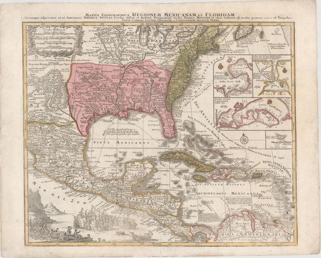
“Mappa Geographica Regionem Mexicanam et Floridam Terrasque Adjacentes, ut et Anteriores Americae Insulas, Cursus Itidem et Reditus Navigantium Versus Flumen Missisipi...”
Map Maker:
Seutter/Lotter
This is one of the many versions of Delisle's impo... (full text available to subscribers)
| Item Detail |
| |
| |
MapMaker: |
Seutter/Lotter
|
|
| |
| |
Subject: |
Colonial North America & Caribbean |
|
| |
Period/Size: |
1770 / 19.6" x 22.9" (49.8 x 58.2 cm)
|
|
| |
Color: |
Colored
|
|
| |
Condition: |
(A) Original color on watermarked paper with a small, professionally repaired hole in sea battle scene and a couple of minute worm holes, only visible when held to light. (condition help) |
|
| |
Source: |
|
|
| |
References: |
Martin & Martin, plt. 18. |
|
| |
|
|
| Sales Information |
| |
| |
Price: |
|
|
| |
| |
Offered by: |
Old World Auctions |
|
| |
Catalog: |
Auction No. 148 - Antique Maps, Charts, Atlases & Globes (9227) |
|
| |
Lot/Item #: |
101 |
|
| |
| |
Date: |
02/2014
|
|
| |
| |
|
Antique Maps - Valuation and Pricing, Descriptions, Resources |
|
Home |
Information |
Search |
Register |
Contact Us |
Site Map
Americana Exchange, Inc. © 1999 - 2024 Americana Exchange, Inc.. All rights reserved.
OldMaps.com, the OldMaps.com logo and
AMPR are service marks or registered service marks of Americana Exchange, Inc..
|