Title:
“Map of the Various Lines between the United States and the British Provinces”
Map Maker:
James Duncan Graham
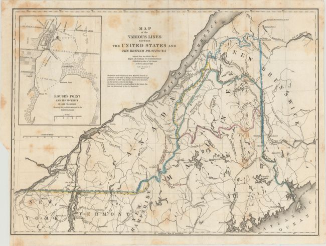
The finely engraved map shows the disputed borders... (full text available to subscribers)
| Item Detail |
| |
| |
MapMaker: |
James Duncan Graham
|
|
| |
| |
Subject: |
Eastern United States & Canada |
|
| |
Period/Size: |
1846 / 11.8" x 15.5" (30.0 x 39.4 cm)
|
|
| |
Color: |
Colored
|
|
| |
Condition: |
(B) Issued folding with moderate foxing in the image and two tiny pinholes in the lower left and right corner of the neatline only visible when held to light. Binding trim at lower left. Report contents are good with light toning and occasional foxing. (condition help) |
|
| |
Source: |
Mr. Webster's Vindication of the Treaty of Washington in 1842ģ |
|
| |
References: |
|
|
| |
|
|
| Sales Information |
| |
| |
Price: |
|
|
| |
| |
Offered by: |
Old World Auctions |
|
| |
Catalog: |
Auction No. 148 - Antique Maps, Charts, Atlases & Globes (9227) |
|
| |
Lot/Item #: |
132 |
|
| |
| |
Date: |
02/2014
|
|
| |
| |
|
Antique Maps - Valuation and Pricing, Descriptions, Resources |
|
Home |
Information |
Search |
Register |
Contact Us |
Site Map
Americana Exchange, Inc. © 1999 - 2024 Americana Exchange, Inc.. All rights reserved.
OldMaps.com, the OldMaps.com logo and
AMPR are service marks or registered service marks of Americana Exchange, Inc..
|