Title:
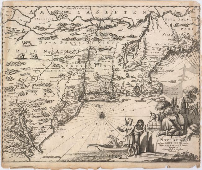
“Novi Belgii, quod nunc Novi Jorck Vocatur, Novae qz. Angliae & Partis Virginiae Accuratissima et Novissima Delineatio”
Map Maker:
Arnoldus Montanus
This finely engraved map is based on the influenti... (full text available to subscribers)
| Item Detail |
| |
| |
MapMaker: |
Arnoldus Montanus
|
|
| |
| |
Subject: |
Colonial New England & Mid-Atlantic United States |
|
| |
Period/Size: |
1671 / 11.5" x 14.6" (29.3 x 37.1 cm)
|
|
| |
Color: |
Black & White
|
|
| |
Condition: |
(B) A dark impression with tattered edges at left, right, and bottom, leading to a few short edge tears that enter 1/8" to 1/2" into the image and a small portion of missing neatline at top left. There are light damp stains on the right and left edges of (condition help) |
|
| |
Source: |
De Nieuwe en Onbekende Weereld |
|
| |
References: |
Campbell (MCC-24) #21; McCorkle #671.1. |
|
| |
|
|
| Sales Information |
| |
| |
Price: |
|
|
| |
| |
Offered by: |
Old World Auctions |
|
| |
Catalog: |
Auction No. 148 - Antique Maps, Charts, Atlases & Globes (9227) |
|
| |
Lot/Item #: |
170 |
|
| |
| |
Date: |
02/2014
|
|
| |
| |
|
Antique Maps - Valuation and Pricing, Descriptions, Resources |
|
Home |
Information |
Search |
Register |
Contact Us |
Site Map
Americana Exchange, Inc. © 1999 - 2024 Americana Exchange, Inc.. All rights reserved.
OldMaps.com, the OldMaps.com logo and
AMPR are service marks or registered service marks of Americana Exchange, Inc..
|