Title:
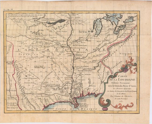
“Carte de la Louisiane Colonie Francaise avec le Cours du Fleuve St. Louis, les Rivieres Adjacentes, les Nations des Naturels, les Stablissems. Franciase et les Mines”
Map Maker:
Antoine Simon Le Page du Pratz
This scarce map of the heart of French Louisiana c... (full text available to subscribers)
| Item Detail |
| |
| |
MapMaker: |
Antoine Simon Le Page du Pratz
|
|
| |
| |
Subject: |
Colonial Central United States, Louisana |
|
| |
Period/Size: |
1757 / 10.0" x 13.5" (25.4 x 34.3 cm)
|
|
| |
Color: |
Colored
|
|
| |
Condition: |
(B+) Issued folding, now flattened on watermarked paper with minor offsetting and a few spots of foxing. (condition help) |
|
| |
Source: |
Histoire de la Louisiane |
|
| |
References: |
Wheat [TMW] #139. |
|
| |
|
|
| Sales Information |
| |
| |
Price: |
|
|
| |
| |
Offered by: |
Old World Auctions |
|
| |
Catalog: |
Auction No. 148 - Antique Maps, Charts, Atlases & Globes (9227) |
|
| |
Lot/Item #: |
209 |
|
| |
| |
Date: |
02/2014
|
|
| |
| |
|
Antique Maps - Valuation and Pricing, Descriptions, Resources |
|
Home |
Information |
Search |
Register |
Contact Us |
Site Map
Americana Exchange, Inc. © 1999 - 2024 Americana Exchange, Inc.. All rights reserved.
OldMaps.com, the OldMaps.com logo and
AMPR are service marks or registered service marks of Americana Exchange, Inc..
|