Rister or Sign In to see pricing information


Title:

Plan of the Front Part of the City of New Orleans, in 1818

Map Maker:

U.S. Government

Plan of the Front Part of the City of New Orleans, in 1818

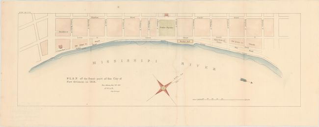
An uncommon map of the front of the early city of ... (full text available to subscribers)
Item Detail
 
  MapMaker:  

U.S. Government


  Subject:  New Orleans, Louisiana  
  Period/Size:  1827 / 7.3" x 22.0"  (18.6 x 55.9 cm)  
  Color:  Colored  
  Condition:  (B+) Issued folding with good margins and a light damp stain along one fold. (condition help)  
  Source:  State Papers of U.S. 20th Cong., 1st Session  
  References:  Claussen & Friis #11.  
 
 
Sales Information
 
  Price: 

Please register your email to view records, or sign in with email address to see records


  Offered by:  Old World Auctions  
  Catalog:  Auction No. 148 - Antique Maps, Charts, Atlases & Globes (9227)  
  Lot/Item #:  265  
 
  Date:  02/2014  


Antique Maps - Valuation and Pricing, Descriptions, Resources


Home | Information | Search | Register | Contact Us | Site Map

Americana Exchange, Inc. © 1999 - 2024 Americana Exchange, Inc.. All rights reserved. OldMaps.com, the OldMaps.com logo and
AMPR are service marks or registered service marks of Americana Exchange, Inc..